 |
Sallows |
 |
 |
Map and Photo Gallery |
 |
|
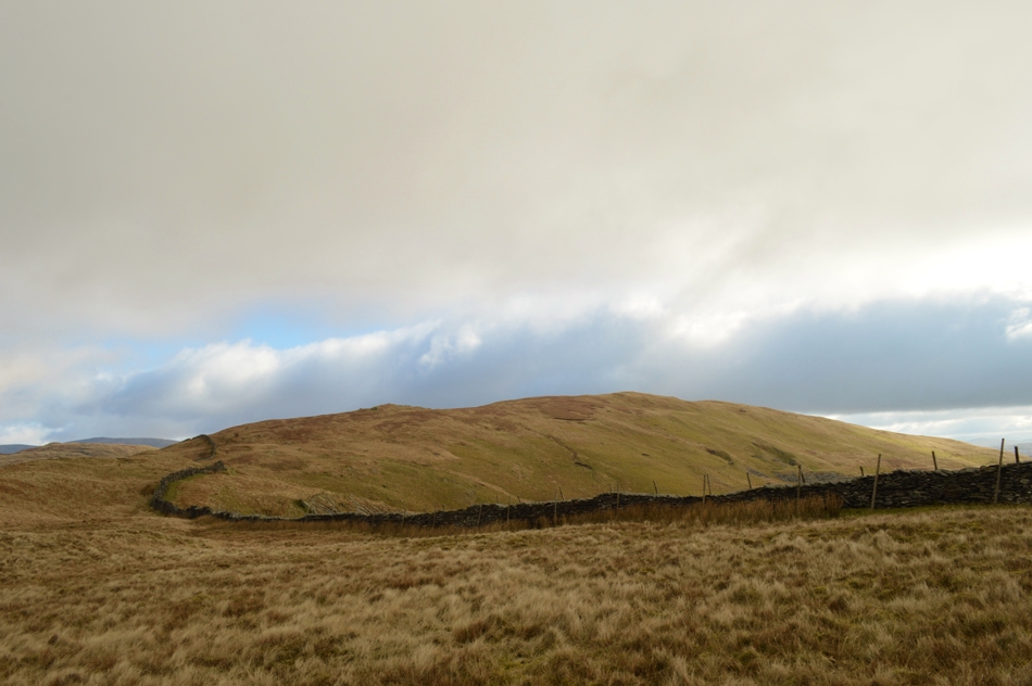 |
| Sallows seen over Moor Head. |
|
| |
|
There are 9 walks to choose from including Sallows |
|
|
Sour Howes & Sallows from Dubbs Road |
|
|
 |
|
2nd June 2022 |
| ASCENT: |
1,329 Feet - 405 Metres |
| MILES: |
17.2 |
| WAINWRIGHTS: |
2, Sour Howes - Sallows |
| ROUTE: |
Dubbs Road – Dubbs Reservoir – Garburn Pass – Backstone Barrow – Sour Howes – Moor Head – Sallows – Long Crag – Kentmere/Ings Bridleway – Mickle Moss – High Borrans – Borrans Lane – Moorhowe Road - Dubbs Road |
|
| |
|
Thornthwaite Crag via the Ill Bell Ridge |
|
|
|
|
19th April 2019 |
| ASCENT: |
3,529 Feet - 1,076 Metres |
| MILES: |
11.4 |
| WAINWRIGHTS: |
6, Sour Howes - Sallows - Yoke - III Bell - Froswick - Thornthwaite Crag |
| ROUTE: |
Church Bridge - Garburn Pass - Sour Howes - Moor Head - Sallows - Yoke - Ill Bell - Froswick -Thornthwaite Crag - Scots Rake - Hag Gill - Troutbeck Park - Ing Bridge - Ing Lane - Truss Lane - Troutbeck Church - Church Bridge |
|
| |
|
Before the rain came, Sallows and Sour Howes from Church Bridge |
|
|
|
|
24th September 2016 |
| ASCENT: |
1,935 Feet - 591 Meters |
| MILES: |
7.7 |
| WAINWRIGHTS: |
2, Sallows - Sour Howes |
| ROUTE: |
Church Bridge - Jesus Church - The Howe - Garburn Pass - Garburn Nook - Sallows - Wardles - Capple Howe- Sour Howes - Backstone Barrow - Dubbs Road - Dubbs Reservoir - Moorhowe Road - Longmire Road - The Howe - Jesus Church - Church Bridge |
|
| |
|
Walking the Wainwrights in 30 Walks - Walk 10 A Troutbeck Circuit |
|
|
|
|
16th April 2016 |
| ASCENT: |
4,406 Feet - 1,344 Meters |
| MILES: |
15 |
| WAINWRIGHTS: |
9, Sour Howes - Sallows - Yoke - III Bell - Froswick - Thornthwaite Crag - Gray Crag - Troutbeck Tongue - Wansfell |
| ROUTE: |
Troutbeck Bridge - Garburn Pass - Sour Howes - Sallows - Yoke - III Bell - Froswick - Thornthwaite Crag - Gray Crag - Thornthwaite Crag - Scotts Rake - Troutbeck Tounge - Trout Beck - Kirkstone Pass - Iddle Hill - Baystones - Wansfell Pike - Nanny Lane - Troutbeck - Troutbeck Bridge |
|
| |
|
New Years Day on Sour Howes and Sallows |
|
|
|
|
1st January 2016 |
| ASCENT: |
1,700 Feet - 518 Meters |
| MILES: |
7.8 |
| WAINWRIGHTS: |
2, Sour Howes - Sallows |
| ROUTE: |
Dubbs Road – Dubbs Reservoir – Garburn Pass – Backstone Barrow – Sour Howes – Moor Head – Sallows – Long Crag – Kentmere/Ings Bridleway – Mickle Moss – High Borrans – Borrans Lane – Moorhowe Road - Dubbs Road |
|
| |
|
Orrest Head, Sour Howes & Sallows |
|
|
|
|
16th March 2014 |
| ASCENT: |
1,650 Feet, 503 Meters |
| MILES: |
10.8 |
| WAINWRIGHTS: |
3, Sour Howes – Sallows – Scour Rigg |
| ROUTE: |
A591 – Orrest Head – Near Orrest – Dubbs Road – Dubbs Reservoir – Garburn Pass – Backstone Barrow – Sour Howes – Moor Head – Sallows – Scour Rigg – Kentmere/Ings Bridleway – Mickle Moss – High Borrans – Borrans Lane – The Common Farm – A591 |
|
| |
|
Thornthwaite Crag via the Ill Bell Ridge |
|
|
|
|
10th December 2011 |
| ASCENT: |
3,780 Feet, 1,152 Meters |
| MILES: |
11.6 |
| WAINWRIGHTS: |
7, Sour Howes, Sallows, Yoke, Ill Bell, Froswick, Thornthwaite Crag, Troutbeck Tongue |
| ROUTE: |
Troutbeck Church – Garburn Road – Sour Howes – Garburn Nook – Garburn Pass – Yoke – Ill Bell – Froswick – Thresthwaite Mouth – Troutbeck Tongue – Ings Lane – Truss Lane – Troutbeck Church |
|
| |
|
Making it up as I go along in Troutbeck |
|
|
|
|
2nd September 2011 |
| ASCENT: |
2,824 Feet, 861 Meters |
| MILES: |
12.9 |
| WAINWRIGHTS: |
4, Sour Howes, Sallows, Troutbeck Tongue & Wansfell Pike |
| ROUTE: |
|
|
| |
|
The Kentmere Horseshoe |
|
|
|
|
6th March 2011 |
| ASCENT: |
4,040 Feet - 1,231 Metres |
| MILES: |
13.9 |
| WAINWRIGHTS: |
10, Sallows, Yoke, III Bell, Froswick, Thornthwaite Crag, High Street, Mardale III Bell, Harter Fell (Mardale), Kentmere Pike & Shipman Knotts |
| ROUTE: |
Kentmere - Garburn Pass - Sallows - Yoke - III Bell - Froswick - Thornthwaite Crag - High Street - Mardale III Bell - Harter Fell - Brown Howe - Kentmere Pike - Shipman Knotts - Stile End - High Lane - Kentmere |
|
| |
| Back to top |
 |
|

