 |
Red Screes |
 |
 |
Map and Photo Gallery |
 |
|
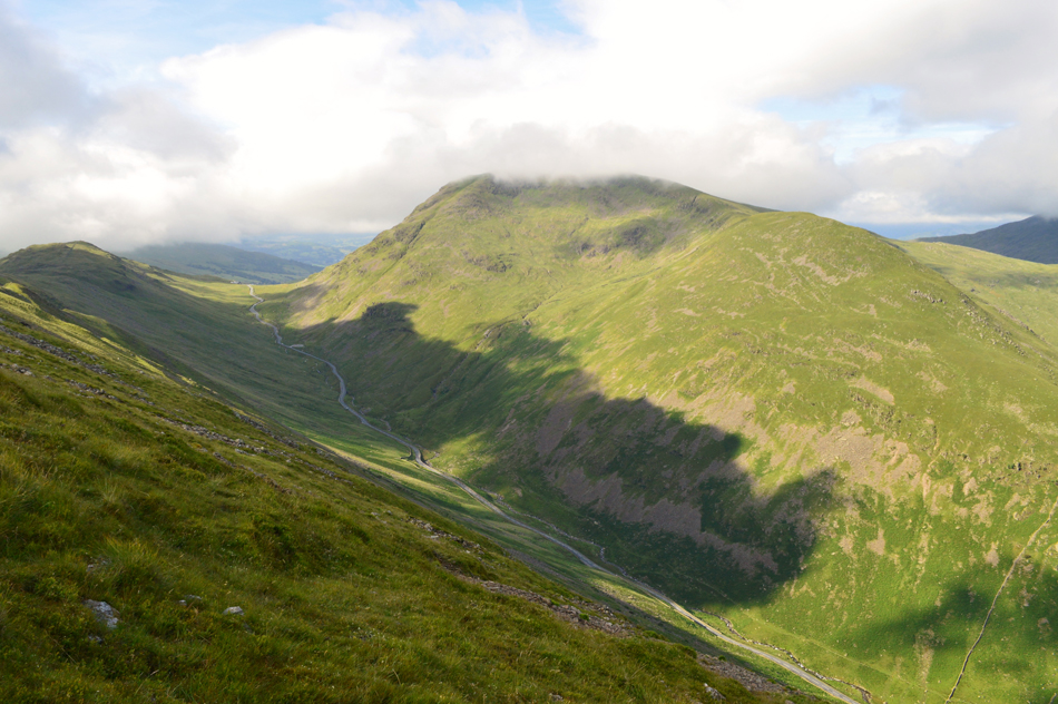 |
| Red Screes and Middle Dodd seen over Kirkstone Pass. |
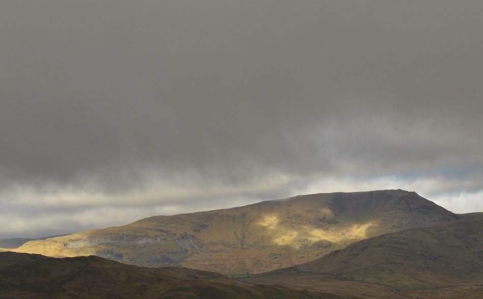 |
| Snarker Pike, Pets Quarry and Red Screes seen from the Garburn Pass. |
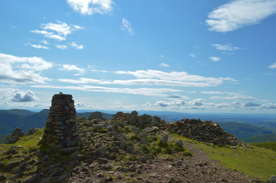 |
| Red Screes summit and Trig Point. |
|
| |
|
There are 13 walks to choose from including Red Screes |
|
|
Kirkstone Pass to Dunmail Raise |
|
|
 |
|
5th April 2025 |
| ASCENT: |
3,052 Feet - 930 Metres |
| MILES: |
7.5 |
| WAINWRIGHTS: |
6, Red Screes - Little Hart Crag - Dove Crag - Hart Crag - Fairfield - Seat Sandal |
| ROUTE: |
Top of Kirkstone Pass - Red Screes - Top of Scandale Pass - Little Hart Crag - Bakestones Moss - Dove Crag - Hart Crag - Link Hause - Fairfield - Grisedale Hause - Seat Sandal - Raise Beck - Dunmail Raise |
|
| |
|
A Scandale Round |
|
|
|
|
9th May 2024 |
| ASCENT: |
3,280 Feet - 999 Metres |
| MILES: |
10 |
| WAINWRIGHTS: |
4, Low Pike - High Pike - Little Hart Crag - Red Screes |
| ROUTE: |
Miller Bridge - Rothay Park - Ambleside - Nook Lane - Nook End Farm - Low Sweden Bridge - Low Pike - High Pike - Scandale Head - Bakestones Moss - Little Hart Crag - Red Screes - Raven Crag - Snarker Pike - Kirkstone Road - Ambleside - Rothay Park - Miller Bridge |
|
| |
|
Scandale, Red Screes and Snarker Pike |
|
|
|
|
20th June 2020 |
| ASCENT: |
2,564 Feet - 782 Metres |
| MILES: |
8.5 |
| WAINWRIGHTS: |
2, Middle Dodd - Red Screes |
| ROUTE: |
Old Lake Road, Ambleside - Sweden Bridge Lane - Scandale - Scandale Pass - Middle Dodd - Smallthwaite Band - Red Screes - Snarker Moss - Snarker Pike - Kirkstone Road - Old Lake Road Ambleside |
|
| |
|
Walking the Birketts, Red Screes by Hartsop Round |
|
|
|
|
11th May 2019 |
| ASCENT: |
2,652 Feet - 808 Metres |
| MILES: |
5.6 |
| BIRKETTS: |
4, Middle Dodd - Red Screes - Little Hart Crag - High Hartsop Dodd |
| ROUTE: |
Kirsktone Pass - Kirkstone Beck - Middle Dodd - Smallthwaite Band - Red Screes - Top of Scandale Pass - Scandale Tarn - Little Hart Crag - High Hartsop Dodd - Caiston Beck - Kirkstone Pass |
|
| |
|
Wansfell, Woundale & Red Screes from Ambleside. |
|
|
|
|
12th May 2018 |
| ASCENT: |
3,823 Feet - 1,161 Metres |
| MILES: |
11.4 |
| WAINWRIGHTS: |
2, Wansfell Pike - Red Screes |
| ROUTE: |
Ambleside - Skelghyll Wood - Kelsick Scar - Wansfell Pike - Baystones (Wansfell) - Idle Hill - Kirkstone Pass - Woundale - St Raven's Edge - Top of Kirkstone Pass - Red Screes - Snarker Pike - Kirkstone Road - Ambleside |
|
| |
|
Walking the Wainwrights in 30 Walks Walk 28 - A Scandale Skyline from Cow Bridge |
|
|
|
|
18th August 2016 |
| ASCENT: |
4,932 Feet - 1,504 Meters
|
| MILES: |
12.5 |
| WAINWRIGHTS: |
9, Hartsop Dodd - Caudale Moor (Stony Cove Pike) - Red Screes - Middle Dodd - Little Hart Crag - High Hartsop Dodd - Dove Crag - Hart Crag - Hartsop above How |
| ROUTE: |
Hartsop - Hartsop Dodd - Caudale Moor (Stony Cove Pike) - John Bell's Banner - St Raven's Edge - Kirkstone Pass - Red Screes - Smallthwaite Band - Middle Dodd - Top of Caiston Beck - Scandale Pass - Little Hart Crag - High Hartsop Dodd - Black Brow - Bakestones Moss - Dove Crag - Hart Crag - Hartsop above How - Gale Crag - Low Wood - Cow Bridge - Hartsop |
|
| |
|
A Kirkstone Skyline |
|
|
|
|
12th March 2016 |
| ASCENT: |
3,130 Feet, 954 Meters |
| MILES: |
8.3 |
| WAINWRIGHTS: |
4, Hartsop Dodd - Caudale Moor (Stonycove Pike) - Red Screes - Middle Dodd |
| ROUTE: |
Cow Bridge - Hartsop Dodd - Caudale Moor (Stony Cove Pike) - St Raven's Edge - Kirkstone Pass Inn - Red Screes - Smallthwaite Band - Middle Dodd - Hartsop Hall - Brothers Water - Cow Bridge |
|
| |
|
The Harry Griffin 2,000 footers Walk 21 -Summits from Kirkstone |
|
|
|
|
25th July 2015 |
| ASCENT: |
2'561 Feet - 781 Meters |
| MILES: |
7.5 |
| SUMMITS OVER 2,000 Ft: |
3, Little Hart Crag West Top - Little Hart Crag East Top - Red Screes |
| ROUTE: |
Cow Bridge - Brothers Water - Hartsop Hall - Caiston Glen - Top of Scandale Pass - Little Hart Crag - Scandale Tarn - Top of Scandale Pass - Red Screes - Smallthwaite Band - Middle Dodd - Hartsop Hall - Brothers Water - Cow Bridge |
|
| |
|
An alternative Fairfield Horseshoe |
|
|
|
|
29th November 2014 |
| ASCENT: |
4,500 Feet – 1,372 Meters |
| MILES: |
13.8 |
| WAINWRIGHTS: |
8, Red Screes – Little Hart Crag – Dove Crag – Hart Crag – Fairfield – Great Rigg – Heron Pike – Nab Scar |
| ROUTE: |
Miller Bridge – Rothay Park – Ambleside – Kirkstone Road – Snarker Pike – Red Screes – Scandale Pass – Little Hart Crag – Bakestones Moss – Dove Crag – Hart Crag – Link Hause – Fairfield – Great Rigg – Heron Pike – Nab Scar – Rydal Hall – Rydal Park – Scandale Bridge – Ambleside – Miller Bridge |
|
| |
|
The Kirkstone Pass Fells |
|
|
|
|
2nd March 2014 |
| ASCENT: |
3,130 Feet, 954 Meters |
| MILES: |
8.3 |
| WAINWRIGHTS: |
4, Hartsop Dodd – Caudale Moor (Stony Cove Pike) – Red Screes – Middle Dodd |
| ROUTE: |
Cow Bridge – Hartsop – Hartsop Dodd – Caudale Moor (Stony Cove Pike) – John Bell’s Banner – St Raven’s Edge – Kirkstone Pass – Red Screes – Middle Dodd – Hartsop Hall – Brothers Water – Cow Bridge |
|
| |
|
Five hours above Scandale |
|
|
|
|
21st September 2012 |
| ASCENT: |
2,191 Feet, 668 Metres |
| MILES: |
9 |
| WAINWRIGHTS: |
4, Red Screes, Little Hart Crag, High Pike & Low Pike |
| ROUTE: |
Kirkstone Road – South Ridge – Snarker Pike – Raven Crag – Red Screes– Little Hart Crag – Scandale Tarn – High Bakestones – Scandale Head – Thack Bottom Edge – High Pike – Low Pike – High Sweden Bridge – Rough Sides – Kirkstone Road |
|
| |
|
The Kirkstone Pass Fells |
|
|
|
|
28th April 2012 |
| ASCENT: |
3,215 Feet, 980 Metres |
| MILES: |
8.8 |
| WAINWRIGHTS: |
4, Middle Dodd, Red Screes, Caudale Moor (Stony Cove Pike) & Hartsop Dodd |
| ROUTE: |
Cow Bridge – Brothers Water – Hartsop Hall – Middle Dodd – Smallthwaite Band – Red Screes – Kirkstone Pass – St Ravens Edge – John Bell’s Banner – Caudale Moor (Stony Cove Pike) – Hartsop Dodd – Hartsop – Cow Bridge |
|
| |
|
Middle Dodd & Red Screes |
|
|
|
|
19th December 2009 |
| ASCENT: |
776Mtrs 2541Ft |
| MILES: |
xxx |
| WAINWRIGHTS: |
2 Middle Dodd, Red Screes |
| ROUTE: |
xxxx |
|
| |
| Back to top |
 |
|

