 |
Wetherlam |
 |
 |
Map and Photo Gallery |
 |
|
 |
| Wetherlam seen over Prison Band from the ascent of Swirl How. |
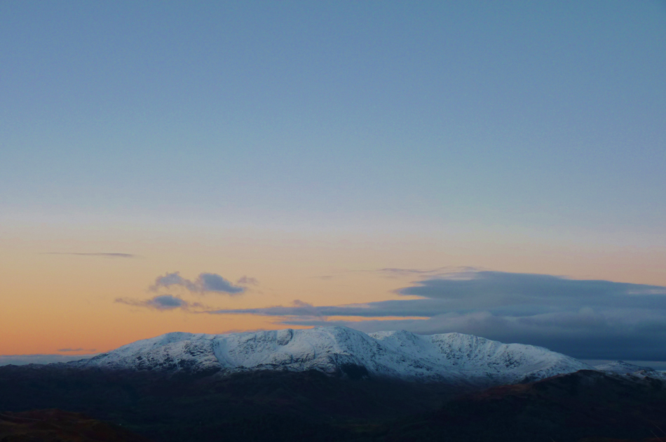 |
| The mass of the Coniston Fells including Wetherlam seen centre taken from Nab Scar summit. |
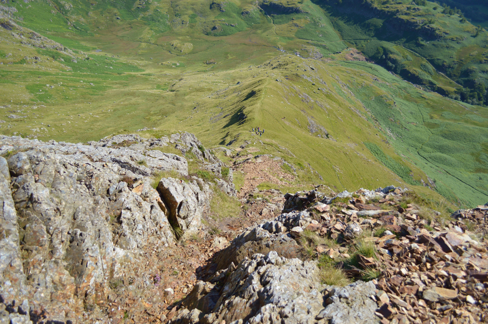 |
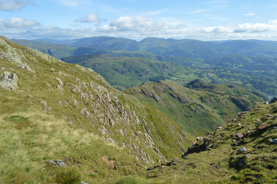
| Looking down on Steel Edge, Wetherlam. |
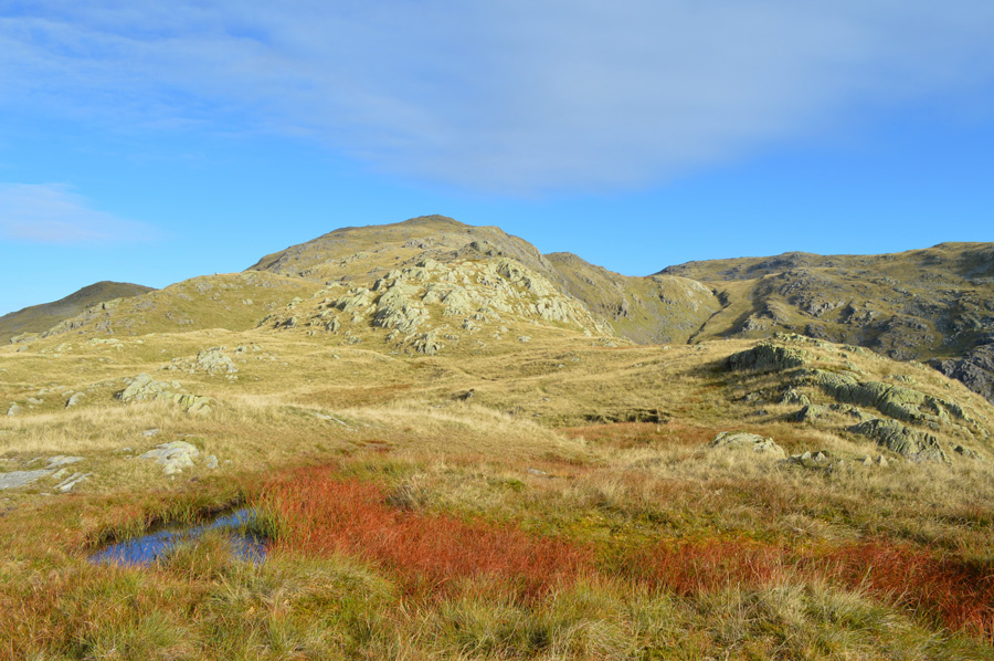 |
| Views towards the top of Black Sails, Red Dell Head and Wetherlam (right) |
 |
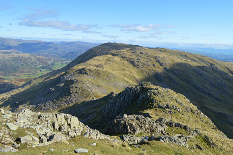
| Wetherlam Edge. |
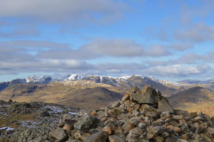 |
| Little Stand, The Scafells, Cold, Pike, Crinkle Crags, Bowfell and Pike O'Blisco from Wetherlam summit. |
|
| |
|
There are 18 walks to choose from including Wetherlam |
|
|
Wetherlam by the Edges |
|
|
 |
|
17th February 2024 |
| ASCENT: |
2,472 Feet - 753 Metres |
| MILES: |
4.7 |
| WAINWRIGHTS: |
Wetherlam |
| ROUTE: |
Tilberthwaite - Tilberthwaite Gill - Dry Cove Bottom - Birk Fell Man - Birk Fell Hawse - Wetherlam Edge - Wetherlam - Lower Hows - Red Gill Head Moss - Steel Edge - Tilberthwaite Gill - Tilberthwaite |
|
| |
|
Steel Edge, Wetherlam & Wet Side Edge from Tilberthwaite |
|
|
|
|
1st May 2023 |
| ASCENT: |
2,946 Feet - 897 Metres |
| MILES: |
9 |
| WAINWRIGHTS: |
3, Wetherlam - Swirl How - Great Carrs |
| ROUTE: |
Tilberthwaite – Above Tilberthwaite Gill – Steel Edge – Wetherlam – Swirl Hawse - Prison Band – Swirl How – Top of Broad Slack – Great Carrs – Wet Side Edge – Greenburn Beck – Low Hall Garth - Slater Bridge (Little Langdale) – Moss Rigg Wood – Tilberthwaite Farm – Tilberthwaite |
|
| |
|
Wetherlam by the Edges |
|
|
|
|
10th December 2022 |
| ASCENT: |
2,472 Feet - 753 Metres |
| MILES: |
4.7 |
| WAINWRIGHTS: |
Wetherlam |
| ROUTE: |
Tilberthwaite - Tilberthwaite Gill - Dry Cove Bottom - Birk Fell Man - Birk Fell Hawse - Wetherlam Edge - Wetherlam - Lower Hows - Red Gill Head Moss - Steel Edge - Tilberthwaite Gill - Tilberthwaite |
|
| |
|
Black Sails and Wetherlam |
|
|
|
|
4th May 2022 |
| ASCENT: |
2,400 Feet - 712 Metres |
| MILES: |
7.3 |
| WAINWRIGHTS: |
Wetherlam |
| ROUTE: |
Ruskin Museum – Miners Bridge – Church Beck – Coppermines Valley – Levers Water – Black Sails – Red Dell Head Moss – Wetherlam – Lad Stones – Hole Rake – Church Beck – Miners Bridge – Ruskin Museum
|
|
| |
|
Black Sails and Wetherlam |
|
|
|
|
2nd November 2019 |
| ASCENT: |
2,400 Feet - 712 Metres |
| MILES: |
7.3 |
| WAINWRIGHTS: |
Wetherlam |
| ROUTE: |
Ruskin Museum – Miners Bridge – Church Beck – Coppermines Valley – Levers Water – Black Sails – Red Dell Head Moss – Wetherlam – Lad Stones – Hole Rake – Church Beck – Miners Bridge – Ruskin Museum
|
|
| |
|
Broad Slack and Wethelam from Elterwater |
|
|
|
|
22nd September 2018 |
| ASCENT: |
3,276 Feet - 999 Metres |
| MILES: |
10 |
| WAINWRIGHTS: |
Wetherlam |
| ROUTE: |
Elterwater - Elterwater Hall - Dale End - Little Langdale - Slater Bridge - Greenburn - Greenburn Reservoir - Broad Slack - Swirl Hawse - Wetherlam - Wetherlam Edge - Slater Bridge - Little Langdale - Dale End - Elterwater Hall - Elterwater |
|
| |
|
Wetherlam Edge, Wetherlam and Steel Edge from Tilberthwaite |
|
|
|
|
18th November 2017 |
| ASCENT: |
2,472 Feet - 753 Metres |
| MILES: |
4.4 |
| WAINWRIGHTS: |
Wetherlam |
| ROUTE: |
Tilberthwaite - Tilberthwaite Gill - Dry Cove Bottom - Birk Fell Man - Birk Fell Hause - Wetherlam Edge - Wetherlam - Steel Edge - Tilberthwaite Gill - Tilberthwaite |
|
| |
|
Steel Edge, Wetherlam and a Cathedral Cave |
|
|
|
|
16th July 2017 |
| ASCENT: |
2,768 Feet - 844 Metres |
| MILES: |
9 |
| WAINWRIGHTS: |
3,Wetherlam - Swirl How - Geat Carrs |
| ROUTE: |
Tilberthwaite – Above Tilberthwaite Gill – Dry Cove Bottom – Steel Edge – Wetherlam – Prison Band – Swirl How – Top Of Broad Slack – Great Carrs – - Wet Side Edge – Greenburn Beck – Slater Bridge (Little Langdale) – Cathedral Quarry – Moss Rigg Wood – Pierce How Beck – Tilberthwaite |
|
| |
|
Black Sails and Wetherlam after the rain |
|
|
|
|
21st May 2017 |
| ASCENT: |
2,400 Feet - 712 Metres |
| MILES: |
7.3 |
| WAINWRIGHTS: |
Wetherlam |
| ROUTE: |
Ruskin Museum – Miners Bridge – Church Beck – Coppermines Valley – Simons Nick – Levers Water – Black Sails – Red Dell Head Moss – Wetherlam – Lad Stones – Hole Rake – Church Beck – Miners Bridge – Ruskin Museum |
|
| |
|
Walking the Wainwrights in 30 Walks - Walk 4 The Coniston Fells |
|
|
|
|
28th February 2016 |
| ASCENT: |
4,500 Feet - 1,372 Meters |
| MILES: |
12.5 |
| WAINWRIGHTS: |
7, Dow Crag - Coniston Old Man - Brim Fell - Grey Friar - Great Carrs - Swirl How - Wetherlam |
| ROUTE: |
Fell Gate - Walna Scar Road - Cove Bridge - Brown Pike - Buck Pike - Dow Crag - Goat's Hawse - Coniston Old Man - Brim Fell - Levers Hawse - Swirl Band - Grey Friar - Fairfield - Great Carrs - Top of Broad Slack - Swirl How - Prison Band - Swirl Hawse - Red Dell Moss - Wetherlam - Black Sails Ridge - Levers Water - Boulder Valley - Walna Scar Road - Fell Gate |
|
| |
|
A Coniston Round |
|
|
|
|
14th October 2015 |
| ASCENT: |
3'967 Feet - 1,209 Meters |
| MILES: |
10.1 |
| WAINWRIGHTS: |
5, Wetherlam - Swirl How - Great Carrs - Brim Fell - Coniston Old Man |
| ROUTE: |
Ruskin Museum - Church Beck - Miners Bridge – Coppermines Valley – Simons Nick – Levers Water – Black Sails – Red Dell Head Moss – Wetherlam – Prison Band - Swirl How - Top of Broad Slack - Great Carrs - Top of Broad Slack - Swirl Band - Levers Hawse - Brim Fell - Coniston Old Man - Low Water - Coppermines Valley - Miners Bridge - Church Beck - Ruskin Museum |
|
| |
|
The Harry Griffin 2,000 footers Walk 3 -The Coniston Fells |
|
|
|
|
13th March 2015 |
| ASCENT: |
4,084 Feet - 1,245 Meters |
| MILES: |
14.1 |
| SUMMITS OVER 2,000 Ft: |
Wetherlam - Wetherlam south cairn - Black Sails - Swirl How - Great Cars - Grey Friar - Brim Fell - Coniston Old Man - Dow Crag - Brown Pike - Walna Scar - White Maide |
| ROUTE: |
Coniston - Sun Hotel - Miners Bridge - Lad Stones - Wetherlam - Black Sails - Swirl Hawse - Prison Band - Swirl How - Great Carrs - Grey Friar - Fairfield - Levers Hawse - Brim Fell - Coniston Old Man - Goats Hawse - Dow Crag - Buck Pike - Brown Pike - Walna Scar - White Maiden - Walna Scar Road - Cove Bridge - Little Arrow Moor - Fell Gate - Sun Hotel - Coniston |
|
| |
|
Black Sails & Wetherlam from Coniston |
|
|
|
|
2nd November 2014 |
| ASCENT: |
2,440 Feet – 712 Meters |
| MILES: |
7.3 |
| WAINWRIGHTS: |
Wetherlam |
| ROUTE: |
Coniston – Miners Bridge – Church Beck – Coppermines Valley – Simons Nick – Levers Water – Black Sails – Red Dell Head Moss – Wetherlam – Lad Stones – Hole Rake – Church Beck – Miners Bridge – Coniston |
|
| |
|
After work, Wetherlam via Steel Edge |
|
|
|
|
31st May 2014 |
| ASCENT: |
2,126 Feet – 648 Meters |
| MILES: |
5.9 |
| WAINWRIGHTS: |
1, Wetherlam |
| ROUTE: |
Tilberthwaite – Tilberthwaite Gill – Dry Cove Bottom – Steel Edge – Lad Stones – Wetherlam – Wetherlam Edge – Birk Fell Hawse – Slater Bridge (Little Langdale) – Cathedral Cave – Moss Rigg Wood – Pierce How Beck – Tilberthwaite |
|
| |
|
Wetherlam, Steel Edge & the Cathedral Cave |
|
|
|
|
1st November 2013 |
| ASCENT: |
3,018 Feet, 920 Meters |
| MILES: |
10.2 |
| WAINWRIGHTS: |
4, Wetherlam – Swirl How – Great Carrs – Grey Friar |
| ROUTE: |
Tilberthwaite – Above Tilberthwaite Gill – Dry Cove Bottom – Steel Edge – Lad Stones – Wetherlam – Prison Band – Swirl How – Top Of Broad Slack – Great Carrs – Fairfield – Grey Friar – Fairfield – Wet Side Edge – Greenburn Beck – Slater Bridge (Little Langdale) – Cathedral Quarry – Moss Rigg Wood – Pierce How Beck – Tilberthwaite |
|
| |
|
Coniston Wonder’s |
|
|
|
|
8th February 2013 |
| ASCENT: |
2,769 Feet, 844 Metres |
| MILES: |
9 |
| WAINWRIGHTS: |
4, Coniston Old Man – Brim Fell – Coniston Old Man – Wetherlam |
| ROUTE: |
Walna Scar – Boo Tarn – Goats Water – Goats Hawes – Coniston Old Man – Brim Fell – Levers Hawse – Swirl Band – Swirl How – Prison Band – Swirl Hawse – Wetherlam – Black Sails South Ridge – Levers Water – Boulder Valley – Walna Scar |
|
| |
|
The Coniston Fells Part II |
|
|
|
|
19th October 2012 |
| ASCENT: |
3,612 Feet, 1,101 Metres |
| MILES: |
8.1 |
| WAINWRIGHTS: |
6, Wetherlam – Swirl How – Great Carrs – Grey Friar – Brim Fell – Coniston Old Man |
| ROUTE: |
Silver Bank – Miners Bridge – Lad Stones – Red Gill Head Moss – Wetherlam – Prison Band – Swirl How – Great Carrs – Grey Friar – Fairfield Col – Swirl Band – Levers Hawse – Brim Fell – Coniston Old Man – Low Water – Boulder Valley – Miners Bridge – Silver Bank |
|
| |
|
Wetherlam & The Old Man Of Coniston |
|
|
|
|
22nd January 2012 |
| ASCENT: |
3,720 Feet |
| MILES: |
7.9 |
| WAINWRIGHTS: |
4, Wetherlam, Swirl How, Brim Fell & The Old Man Of Coniston |
| ROUTE: |
Silver Bank – Miners Bridge – Coppermines Valley – Red Gill – Red Gill Head Moss – Wetherlam – Prison Band – Swirl Hawse – Swirl How – Brim Fell Rake – Brim Fell – The Old Man Of Coniston – Low Water – Boulder Valley – Miners Bridge – Silver Bank |
|
| |
|
Wetherlam, Swirl How & Great Carrs |
|
|
|
|
31st May 2010 |
| ASCENT: |
2,499 Ft 762 Mtrs |
| MILES: |
7 |
| WAINWRIGHTS: |
3, Great Carrs, Swirl How & Wetherlam |
| ROUTE: |
|
|
| |
| Back to top |
 |
|

