 |
Rest Dodd |
 |
 |
Map and Photo Gallery |
 |
|
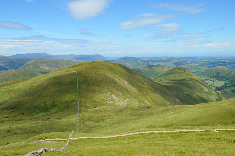 |
| Rest Dodd and The Nabb from The Knott. |
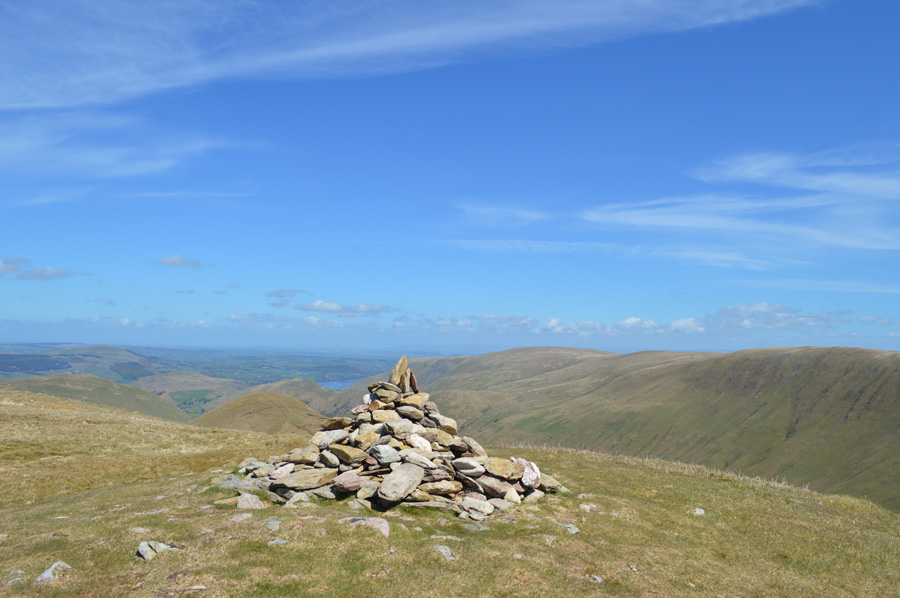 |
| Wetner Hill and Loadpot Hill from Rest Dodd summit. |
|
| |
|
There are 9 walks to choose from including Rest Dodd |
|
|
Martindale's Bannerdale Horseshoe |
|
|
 |
|
6th September 2025 |
| ASCENT: |
2,780 Feet - 847 Metres |
| MILES: |
9.5 |
| WAINWRIGHTS: |
5, Beda Head - Angletarn Pikes - Brock Crags - Rest Dodd - The Nab |
| ROUTE: |
Martindale New Church - Martindale Old Church - Winter Crag - Beda Head (Beda Fell) - Bedafell Knott - Heckbeck Head - Angletarn Pikes - Angletarn Pike South Top - Angle Tarn - Cat Crag - Brock Crags - Satura Crag - Rest Dodd - The Nab - Below Nab End - Martindale - Martindale Old Church - Martindale New Church |
|
| |
|
Angletarn Pikes to Rest Dodd from Hartsop |
|
|
|
|
13th July 2024 |
| ASCENT: |
2,349 Feet - 715 Metres |
| MILES: |
7.2 |
| WAINWRIGHTS: |
3, Angletarn Pikes - Brock Crags - Rest Dodd |
| ROUTE: |
Hartsop - Calf Close - Dub How - Boredale Hause - Angletarn Pikes - Angletarn Pikes South Top - Angle Tarn - Brock Crags - Satura Crag - Rest Dodd - Hayeswater - Hayeswater Gill - Hartsop |
|
| |
|
Walking the Birketts, Martindale's Bannerdale Horseshoe |
|
|
|
|
20th October 2018 |
| ASCENT: |
2,764 Feet - 843 Metres |
| MILES: |
9.5 |
| BIRKETTS: |
6, Beda Head (Beda Fell) - Angletarn Pike North Top - Angletarn Pike South Top - Brock Crags - Rest Dodd - The Nab |
| ROUTE: |
Martindale New Church - Martindale Old Church - Winter Crag - Beda Head (Beda Fell) - Bedafell Knott - Heckbeck Head - Angletarn Pike South Top - Angletarn Pike North Top - Angle Tarn - Cat Crag - Brock Crags - Satura Crag - Rest Dodd - The Nab - Below Nab End - Martindale - Martindale Old Church - Martindale New Church |
|
| |
|
Caudale Moor to Brock Crags via High Street |
|
|
|
|
1st July 2017 |
| ASCENT: |
4,374 Feet - 1,334 Metres |
| MILES: |
14 |
| WAINWRIGHTS: |
10, Caudale Moor (Stoney Cove Pike) - Thornthwaite Crag - High Street - Kidsty Pike - High Raise (Martindale) - Rampsgill Head - The Knott - Rest Dodd - Angletarn Pikes - Brock Crags |
| ROUTE: |
Cow Bridge - Brothers Water - Hartsop Hall - Sykeside - Kirkstone Pass - Caudale Beck - Caudale Quarry - Caudale Moor (Stoney Cove Pike) - Threshthwaite Mouth - Thornthwaite Crag - High Street - Straights of Riggindale - Kidsty Pike - High Raise (Martindale) - Rampsgill Head - The Knott - Rest Dodd - Satura Crag - Angle Tarn - Angletarn Pikes - Cat Crag - Brock Crags - Hartsop - Cow Bridge |
|
| |
|
Walking the Wainwrights in 30 Walks - Walk 20 Fourteen Fells east of Ullswater |
|
|
|
|
3rd July 2016 |
| ASCENT: |
4,790 Feet - 1,460 Meters |
| MILES: |
19.9 |
| WAINWRIGHTS: |
14, Bonscale Fell - Arthurs Pike - Loadpot Hill - Wether Hill - High Raise (Martindale) - Kidsty Pike - Rampsgill Head - High Street - The Knott - Rest Dodd - The Nab - Brock Crags - Angletarn Pikes - Beda Fell |
| ROUTE: |
Martindale New Church - Mellgaurds - Bonscale Pike - Top of Swarth Beck - Arthurs Pike - Loadpot Hill - Wether Hill - Red Crag - High Raise (Martindale) - Rampsgill Head - Kidsty Pike - Straights of Riggindale - High Street - Straights of Riggindale - The Knott - Rest Dodd - The Nab - Satura Crag - Brock Crags - Angletarn Pikes - Heckbeck Head - Beda Knott - Beda Fell - Winter Crag - Martindale Old Church - Martindale New Church |
|
| |
|
The Harry Griffin 2,000 footers Walk 14 -Walking High Street |
|
|
|
|
23rd May 2015 |
| ASCENT: |
3,864 Feet - 1,178 Metres |
| MILES: |
12 |
| SUMMITS OVER 2,000 Ft: |
Loadpot Hill - Wether Hill (NY 456 167) Wether Hill (NY 455 163) - Red Crag - Raven Howe - High Raise - Kidsty Pike - Rampsgill Head - The Knott - Rest Dodd - High Street - Rough Crag |
| ROUTE: |
Martindale New Church - Howtown - Fusedale - Brock Crag - Loadpot Hill - Wether Hill - Red Crag - Raven How - High Raise - Kidsty Pike - Rampsgill Head - The Knott - Straights of Riggindale - High Street - Rough Crag - Mardale Head |
|
| |
|
The Martindale Horseshoe |
|
|
|
|
19th May 2013 |
| ASCENT: |
4,007 Feet, 1,221 Metres |
| MILES: |
12 |
| WAINWRIGHTS: |
9, Beda Fell – Angletarn Pikes – Brock Crags – Rest Dodd – The Knott – Rampsgill Head – High Raise – Wether Hill – Steel Knotts (Pikeawassa) |
| ROUTE: |
Martindale New Church – Martindale Old Church – Winter Crag – Beda Fell – Bedafell Knott – Angletarn Pikes – Brock Crags – Satura Crag – Rest Dodd – The Knott – Rampsgill Head – High Raise – Raven Howe – Red Crag – High Street Roman Road (Course Of) – Wether Hill – Brownthwaite Crag – Steel Knotts (Pikeawassa) – Birkie Knott – Lanty Tarn – Martindale New Church |
|
| |
|
Deluge On The Far Eastern Fells |
|
|
|
|
16th July 2011 |
| ASCENT: |
3,261 Feet, 992 Meters |
| MILES: |
12.5 |
| WAINWRIGHTS: |
7, Beda Fell, Brock Crags, The Knott, Rampsgill Head, High Raise, Rest Dodd & The Nab |
| ROUTE: |
|
|
| |
|
Brock Crags, Rest Dodd & The Knott |
|
|
|
|
28th November 2010 |
| ASCENT: |
2,423 Ft 738.5 Mtrs |
| MILES: |
8.7 |
| WAINWRIGHTS: |
3, Brock Crags, Rest Dodd & The Knott |
| ROUTE: |
|
|
| |
| Back to top |
 |
|

