 |
Branstree |
 |
 |
Map and Photo Gallery |
 |
|
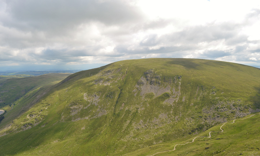 |
| Branstree seen over the Gatesscarth Pass. |
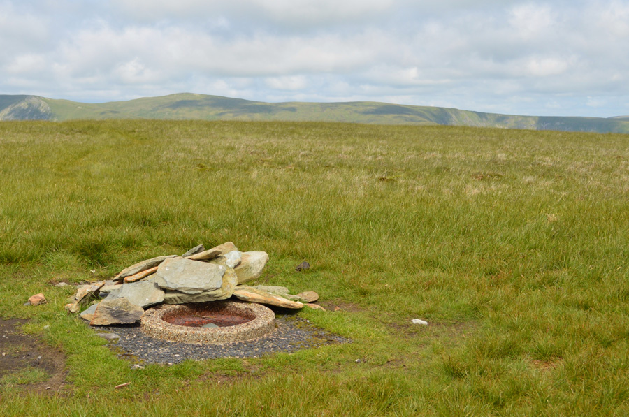 |
| Branstree circular trig point. |
|
| |
|
There are 16 walks to choose from including Branstree |
|
|
Selside Pike, Branstree & Harter Fell from Mardale Head |
|
|
 |
|
25th October 2025 |
| ASCENT: |
2,630 Feet - 801 Metres |
| MILES: |
8.5 |
| WAINWRIGHTS: |
3, Selside Pike - Branstree - Harter Fell (Mardale) |
| ROUTE: |
Mardale Head - Old Corpse Road - Selside End - Selside Pike - Captain Welter Bog - High Howes - Artle Crag - Branstree - Top of Gatescarth Pass - Adam Seat - Harter Fell (Mardale) - Top of Nan Bield Pass - Small Water - Small Water Beck - Mardale Head |
|
| |
|
A High Level Circuit of Mardale Head |
|
|
|
|
20th April 2025 |
| ASCENT: |
3,600 Feet - 1,098 Metres |
| MILES: |
11 |
| WAINWRIGHTS: |
5, High Street - Mardale III Bell - Harter Fell (Mardale) - Branstree - Selside Pike |
| ROUTE: |
Mardale Head - Rough Crag - High Street - Mardale III Bell - Top of Nan Bield Pass - Harter Fell (Mardale) - Top of Gatescarth Pass - Branstree - Artle Crag - Selside Pike - Selside End - Old Corpse Road - Rowantreethwaite Beck - Mardale Head |
|
| |
|
Branstree, Selside Pike & The Old Corpse Road |
|
|
|
|
6th August 2024 |
| ASCENT: |
1,900 Feet - 579 Metres |
| MILES: |
6 |
| WAINWRIGHTS: |
2, Branstree - Selside Pike |
| ROUTE: |
Mardale Head - Gatescarth Pass - Branstree - Artle Crag - High Howes - Captain Whelter Bog - Selside Pike - Selside End - Old Corpse Road - Mardale Head |
|
| |
|
The Old Corpse Road, Selside Pike & Branstree |
p |
|
|
|
31st July 2022 |
| ASCENT: |
1,725 Feet - 526 Metres |
| MILES: |
6.3 |
| WAINWRIGHTS: |
2, Selside Pike - Branstree |
| ROUTE: |
Mardale - Old Corpse Road - Selside End - Selside Pike - Captain Welter Bog - High Howes - Artle Crag - Branstree - Branstree North Ridge - Rowantreethwaite Beck - Mardale |
|
| |
|
Branstree, Selside Pike and the Old Corpse Road |
|
|
|
|
2nd January 2022 |
| ASCENT: |
1,725 Feet - 526 Metres |
| MILES: |
6.3 |
| WAINWRIGHTS: |
2, Branstree - Selside Pike |
| ROUTE: |
Mardale - Rowantreethwaite Beck - Branstree North Ridge - Branstree - Artle Crag - Survey Pillar - High Howes - Captain Whelter Bog - Selside Pike - Selside End - Old Corpse Road - Rowantreethwaite Beck - Mardale |
|
| |
|
Branstree, Selside Pike and the Old Corpse Road |
|
|
|
|
24th June 2020 |
| ASCENT: |
1,725 Feet - 526 Metres |
| MILES: |
6.3 |
| WAINWRIGHTS: |
2, Branstree - Selside Pike |
| ROUTE: |
Mardale - Rowantreethwaite Beck - Branstree North Ridge - Branstree - Artle Crag - Survey Pillar - High Howes - Captain Whelter Bog - Selside Pike - Selside End - Old Corpse Road - Rowantreethwaite Beck - Mardale |
|
| |
|
Branstree, Selside Pike and the Old Corpse Road |
|
|
|
|
11th January 2020 |
| ASCENT: |
1,725 Feet - 526 Metres |
| MILES: |
6.3 |
| WAINWRIGHTS: |
2, Branstree - Selside Pike |
| ROUTE: |
Mardale - Rowantreethwaite Beck - Branstree North Ridge - Branstree - Artle Crag - Survey Pillar - High Howes - Captain Whelter Bog - Selside Pike - Selside End - Old Corpse Road - Rowantreethwaite Beck - Mardale |
|
| |
|
Walking the Birketts, Branstree |
|
|
|
|
11th June 2018 |
| ASCENT: |
1,750 Feet - 533 Metres |
| MILES: |
5 |
| BIRKETTS: |
4, Branstree - High Howes - Selside Pike - Brown Howe |
| ROUTE: |
Mardale - Rowantreethwaite Beck - Branstree North Ridge - Branstree - Artle Crag - Survey Pillar - High Howes - Captain Whelter Bog - Selside Pike - Selside End - Old Corpse Road - Brown Howe - Rowantreethwaite Beck - Mardale |
|
| |
|
A High Level Circuit of Mardale Head |
|
|
|
|
3rd June 2017 |
| ASCENT: |
3,600 Feet - 1,098 Metres |
| MILES: |
11 |
| WAINWRIGHTS: |
5, High Street - Mardale III Bell - Harter Fell (Mardale) - Branstree - Selside Pike |
| ROUTE: |
Mardale Head - Rough Crag - High Street - Mardale III Bell - Top of Nan Bield Pass - Harter Fell (Mardale) - Adam Seat - Top of Gatescarth Pass - Branstree - Artle Crag - Selside Pike - Selside End - Old Corpse Road - Rowantreethwaite Beck - Mardale Head |
|
| |
|
Walking the Wainwrights in 30 Walks - Walk 19 - An extended Longsleddale Circuit |
|
|
|
|
26th June 2016 |
| ASCENT: |
4,495 Feet - 1,371 Meters
|
| MILES: |
14.5 |
| WAINWRIGHTS: |
8, Shipman Knotts - Kentmere Pike - Harter Fell (Mardale) - Mardale III Bell - Branstree - Selside Pike - Grey Crag - Tarn Crag (Longsleddale) |
| ROUTE: |
Sadgill - Longsleddale Pass - Shipman Knotts - Kentmere Pike - Harter Fell (Mardale) - Top of Nan Bield Pass - Mardale III Bell - Top of Nan Bield Pass - Harter Fell - Top of Gatescarth Pass - Branstree - Artle Crag - Selside Pike - Selside Brow - Brownhowe Bottom - Tarn Crag (Longsleddale) - Grey Crag - Great Howe - Sadgill |
|
| |
|
Four remote far eastern fells from Swindale |
|
|
|
|
26th September 2015 |
| ASCENT: |
3,094 Feet - 941 Meters |
| MILES: |
13.7 |
| WAINWRIGHTS: |
4, Selside Pike - Branstree - Grey Crag - Tarn Crag (Longsleddle) |
| ROUTE: |
Swindale Lane - Old Corpse Road - Selside End - Selside Pike - Captain Whelter Bog - Howes - Branstree Tarn - Artle Crag - Branstree - Selside Brow - Brownhowe Bottom - Tarn Crag (Longsleddale) - Greycrag Tarn - Grey Crag - Harrop Pike - Brunt Tongue - Mosedale Beck - Swindale Head - Swindale Lane |
|
| |
|
The Harry Griffin 2,000 footers Walk 2 -The Fringe of Lakeland |
|
|
|
|
8th March 2015 |
| ASCENT: |
3,289 Feet - 1,003 Meters |
| MILES: |
9.6 |
| SUMMITS OVER 2,000 Ft |
Grey Crag (Longsleddale) - Tarn Crag - Branstree - Selside Pike - Adam Seat |
| ROUTE: |
Sadgill - Great Howe - Grey Crag (Longsleddale) - Greycrag Tarn - Tarn Crag - Selside Brow - Branstree - Artle Crag - Selside Pike - Branstree - Gatescarth Pass - Adam Seat - Gatescarth Pass - Sadgill |
|
| |
|
Tarn Crag from Swindale |
|
|
|
|
2nd March 2013 |
| ASCENT: |
2,000 Feet 609 Metres |
| MILES: |
10.5 |
| WAINWRIGHTS: |
4, Selside Pike – Branstree – Tarn Crag (Longsleddale) – Grey Crag |
| ROUTE: |
Truss Gap – Old Corpse Road – Selside End – Selside Pike – Artle Crag – Branstree – Selside Brow – Tarn Crag (Longsleddale) – Greycrag Tarn – Grey Crag – Harrop Pike – Mosedale Beck – Nabs Moor – Swindale Head – Truss Gap |
|
| |
|
Branstree, Moasdale & The Old Corpse Road |
|
|
|
|
21st July 2012 |
| ASCENT: |
2,142 Feet, 653 Metres |
| MILES: |
7.5 |
| WAINWRIGHTS: |
1, Branstree |
| ROUTE: |
Haweswater Road – Hopgill Beck – Branstree North Ridge – Branstree – Selside Brow – Mosedale – Mosedale Cottage – Mosedale Beck – Swindale Head – The Old Corpse Road – Haweswater Road |
|
| |
|
The Remote Far Eastern Fells |
|
|
|
|
29th April 2011 |
| ASCENT: |
1,971 Feet, 601 Meters |
| MILES: |
9.7 |
| WAINWRIGHTS: |
4, Grey Crag (Longsleddale), Tarn Crag (Longsleddale), Branstree & Selside Pike |
| ROUTE: |
|
|
| |
| Back to top |
 |
|

