 |
Rossett Pike |
 |
 |
Map and Photo Gallery |
 |
|
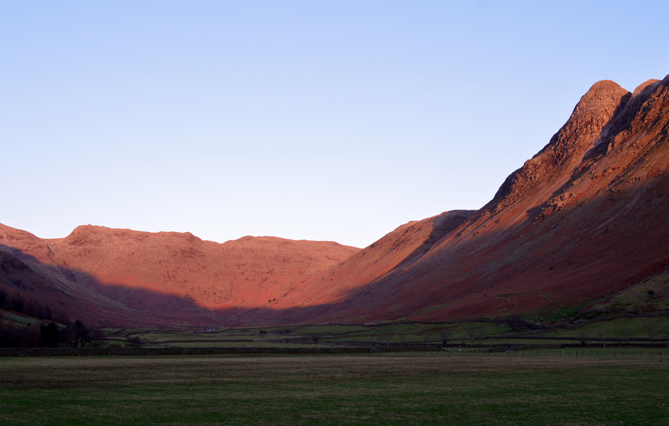 |
| Rossett Pike (centre) and Pike O'Stickle seen from Mickleden. |
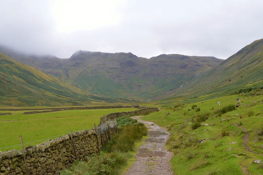 |
| Rossett Pike seen from Mickleden. |
|
| |
|
There are 8 walks to choose from including Rossett Pike |
|
|
Bow Fell, Esk Pike & Rossett Pike from ODG |
|
|
 |
|
10th October 2025 |
| ASCENT: |
3,516 Feet - 1,071 Metres |
| MILES: |
9.5 |
| WAINWRIGHTS: |
4, Bow Fell - Esk Pike - Allen Crags - Rossett Pike |
| ROUTE: |
ODG - Stool End Farm - The Band - Climbers Traverse - Great Slab - Bow Fell - Ore Gap - Esk Pike - Esk Hause - Allen Crags - Esk Hause - Tongue Head - Angle Tarn - Rossett Pike - Rossett Gill - Cumbrian Way - ODG
|
|
| |
|
Rossett Pike from Stonethwaite |
|
|
|
|
10th July 2021 |
| ASCENT: |
2,316 Feet 706 Metres |
| MILES: |
12.5 |
| WAINWRIGHTS: |
Rossett Pike |
| ROUTE: |
Stonethwaite - Langstrath - Blea Rock - Blackmoss Pot - Stake Pass - Rossett Pike - Angle Tarn - Angletarn Gill - Langstrath - Tray Dub - Blackmoss Pot - Stonethwaite Campsite - Stonethwaite |
|
| |
|
Walking the Wainwrights in 30 Walks Walk 26 - The head of Great Langdale |
|
|
|
|
13th August 2016 |
| ASCENT: |
4,989 Feet - 1,521 Meters |
| MILES: |
12.8 |
| WAINWRIGHTS: |
6, Rossett Pike - Esk Pike - Bowfell - Crinkle Crags - Cold Pike - Pike O'Blisco |
| ROUTE: |
Old Dungeon Ghyll - Mickleden - Cumbrian Way - Rossett Gill - Rossett Pike - Angle Tarn - Esk Hause - Esk Pike - Ore Gap - Bowfell - Three Tarns - Crinkle Crags - Cold Pike - Red Tarn - Pike O'Blisco - Wrynose Fell - Redacre Gill - Wall End - Old Dungeon Ghyll |
|
| |
|
The Harry Griffin 2,000 footers Walk 9 -The Scafells Ridge |
|
|
|
|
4th May 2015 |
| ASCENT: |
4,428 Feet - 1,350 Metres |
| MILES: |
14 |
| SUMMITS OVER 2,000 Ft: |
Rossett Pike - Esk Pike - Great End - III Crag North Top - III Crag - Broad Crag - Rough Crag - Pen |
| ROUTE: |
ODG - Mickleden - Rossett Gill - Rossett Pike - Angle Tarn - Ore Gap - Esk Pike - Esk Hause - Calf Cove - Great End - Ill Crag North Top - III Crag - Broad Crag - Broad Crag Col - Little Narrowcove - Rough Crag - Pen - Ill Crag South Scree - Calf Cove - Esk Hause - Angle Tarn - Rossett Gill - Mickleden - ODG |
|
| |
|
Scafell Pike from Dunmail Raise |
|
|
|
|
3rd May 2014 |
| ASCENT: |
5,800 Feet 1,768 Meters |
| MILES: |
16.8 |
| WAINWRIGHTS: |
10, Steel Fell – Calf Crag – Sergeant Man – Thunacar Knott – Pavey Ark – Harrison Stickle – Pike O’ Stickle – Rossett Pike – Great End – Scafell Pike |
| ROUTE: |
Dunmail Raise – Steel Fell – Steelfell Tarn – Calf Crag – Brownrigg Tarn – Codale Head – Sergeant Man – Thunacar Knott – Pavey Ark – Harrison Stickle – Pike O’Stickle – Martcrag Moor – Stake Pass – Rossett Pike – Angle Tarn (Langstrath) – Esk Hause – Calf Cove – Great End – Broad Crag Col – Scafell Pike – Corridor Route – Styhead – Styhead Gill – Stockley Bridge – Seathwaite |
|
| |
|
‘A grand day for it’ Bow Fell to Esk Pike |
|
|
|
|
2nd December 2012 |
| ASCENT: |
966 Metres, 3,169 Feet |
| MILES: |
9.8 |
| WAINWRIGHTS: |
4, Bow Fell – Esk Pike – Allen Crags – Rossett Pike |
| ROUTE: |
Old Dungeon Ghyll – Stool End Farm – The Band – Three Tarns – Bow Fell – Ore Gap – Esk Pike – Esk Hause – Allen Crags – Angle Tarn (Langstrath) – Rossett Pike – Cumbrian Way – Rossett Gill – Mickleden – Old Dungeon Ghyll |
|
| |
|
High on Langstrath |
|
|
|
|
20th May 2012 |
| ASCENT: |
3,850 Feet, 1,173 Metres |
| MILES: |
12.5 |
| WAINWRIGHTS: |
4, Eagle Crag, Sergeant’s Crag, High Raise, Rossett Pike |
| ROUTE: |
Stonethwaite – Greenup Gill – Eagle Crag – Sergeant’s Crag – Low White Stones – High Raise – Stake Pass – Buck Pike – Rossett Pike – Angle Tarn – Langstrath Valley – Tray Dub – Blackmoss Pot – Stonethwaite |
|
| |
|
Pike O’Stickle |
|
|
|
|
10th October 2010 |
| ASCENT: |
2,916 Ft 888.7 Mtrs |
| MILES: |
9.25 |
| WAINWRIGHTS: |
4 Loft Crag, Pike O’Stickle, Thunacar Knott & Rossett Pike |
| ROUTE: |
|
|
| |
| Back to top |
 |
|

