 |
Dollywaggon Pike |
 |
 |
Map and Photo Gallery |
 |
|
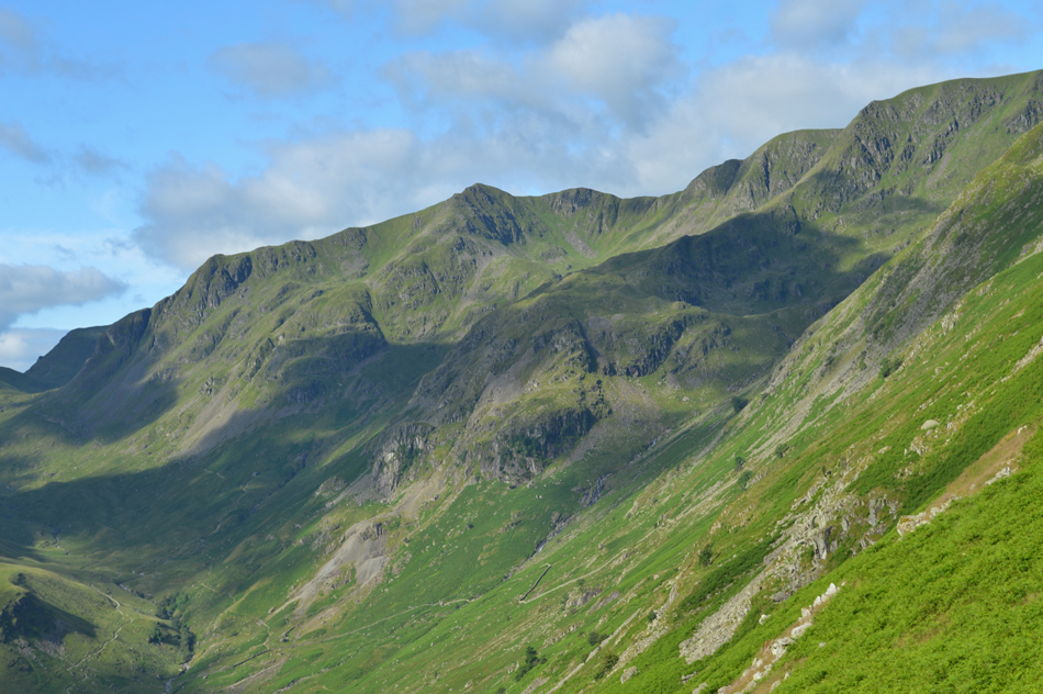 |
| A close up of Nethermost Pike, Nethermost Cove, Nethermost Pike East Ridge, High Crag, The Tongue, Ruthwaite Cove and Dollywaggon Pike. |
 |
| Dollywaggon Pike seen over Ruthwaite Cove. |
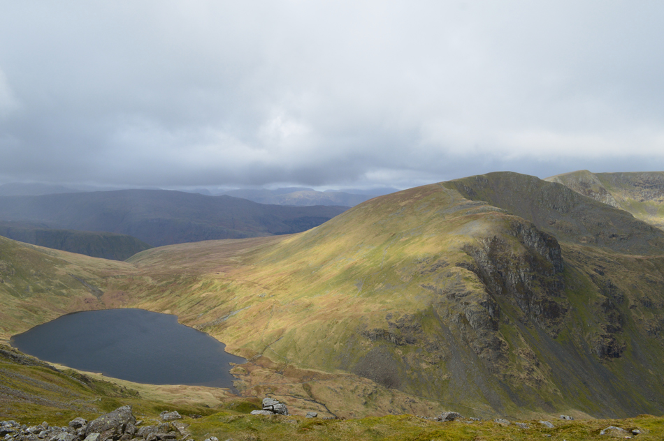 |
| Dollywaggon Pike and Grisedale Tarn seen from Cofa Pike. |
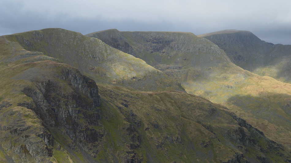 |
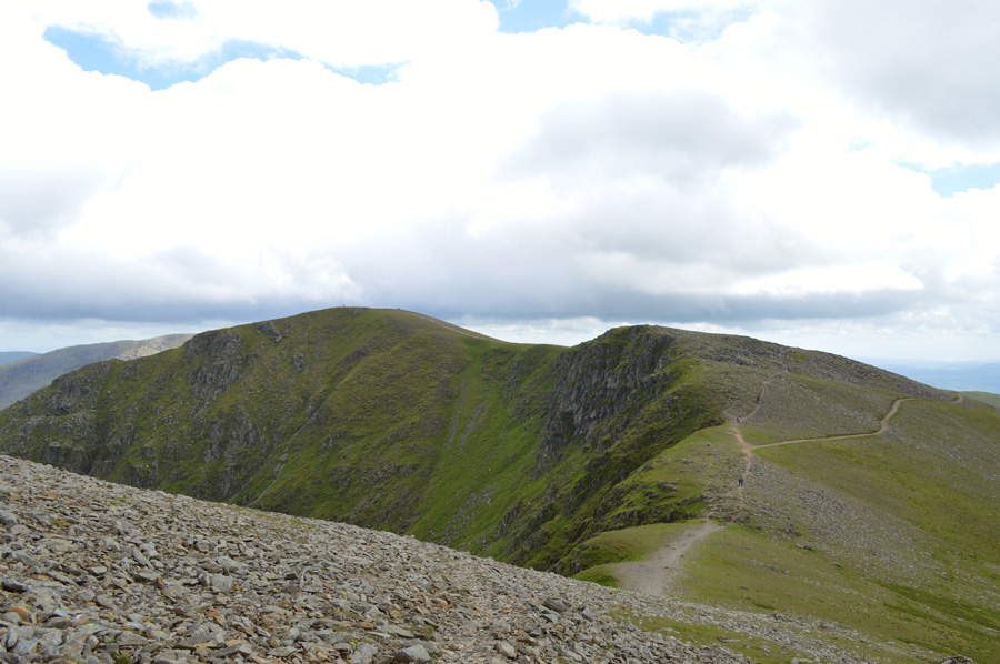
| Dollywaggon Pike, The Tongue, Ruthwaite Cove, Nethermost Pike, Nethermost Cove, Nethermost Pike east ridge, Helvellyn and Striding Edge. |
 |
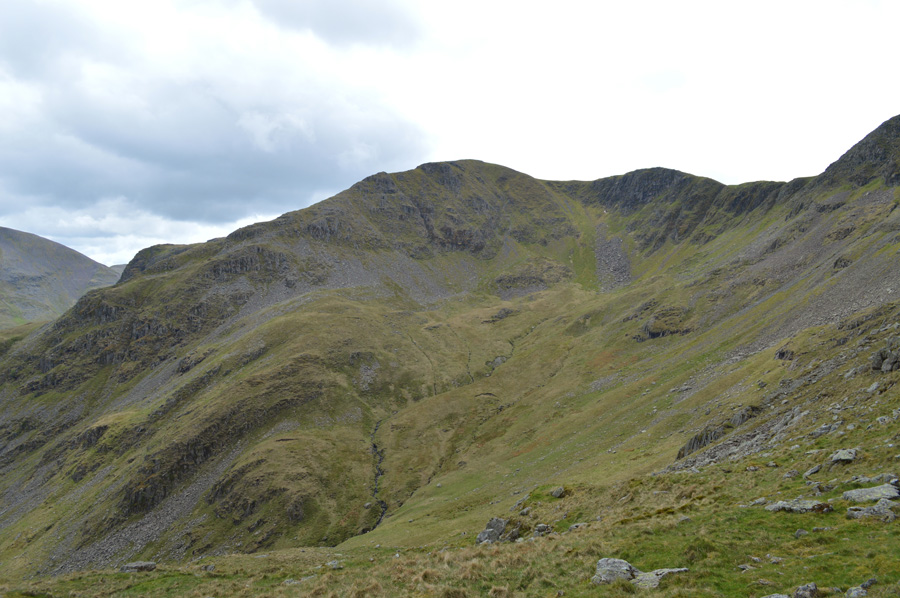
| High Crag and Dollywaggon Pike seen over Ruthwaite Cove. |
 |
| Dollywaggon Pike and The Tongue from Ruthwaite Cove. |
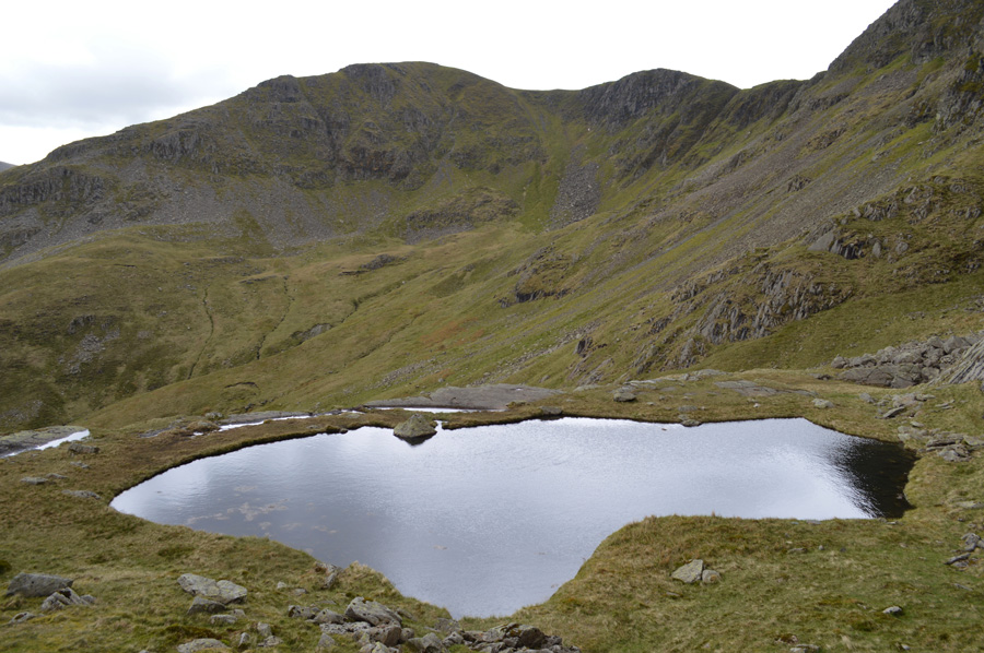 |
| Dollywaggon Pike, The Tongue from Hard Tarn. |
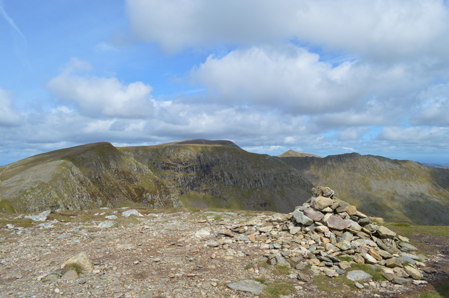 |
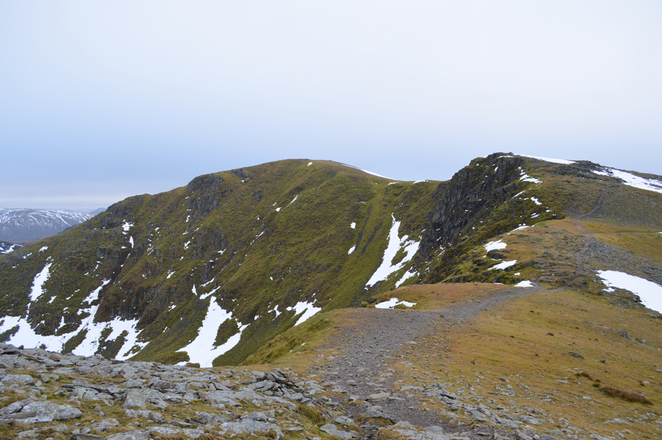
| High Crag, Nethermost Pike, Helvellyn, Striding Edge and Catstye Cam from Dollywaggon Pike summit. |
|
| |
|
There are 12 walks to choose from including Dollywaggon Pike |
|
|
Dollywaggon Pike to Helvellyn via Raise Beck |
|
|
 |
|
5th June 2026 |
| ASCENT: |
3,001 Feet - 914 Metres |
| MILES: |
7.3 |
| WAINWRIGHTS: |
3, Dollywaggon Pike - Nethermost Pike - Helvellyn |
| ROUTE: |
Top of Dunmail Raise - Raise Beck - Grisedale Tarn - Dollywaggon Pike - High Crag - Nethermost Pike - Helvellyn - Birks - Forestry Path back to Wythburn - Birkside Gill - Permissive Path - Raise Beck Ford - Top of Dunmail Raise |
|
| |
|
Helvellyn, Dollwaggon Pike & The Grisedale Valley |
|
|
|
|
31st August 2024 |
| ASCENT: |
3,108 Feet - 947 Metres |
| MILES: |
10 |
| WAINWRIGHTS: |
3, Helvellyn - Nethermost Pike - Dollywaggon Pike |
| ROUTE: |
Patterdale - Grisedale Lane - Grisedale Brow - Hole-in-the-Wall - Red Tarn - Swirral Edge - Helvellyn - Nethermost Pike - High Crag - Dollywaggon Pike - The Tongue - Ruthwaite Lodge - Grisedale - Elmhow - Grisedale Lane - Patterdale |
|
| |
|
Helvellyn to Dollywaggon Pike from Swirls |
|
|
|
|
4th January 2020 |
| ASCENT: |
3,050 Feet - 930 Metres |
| MILES: |
6.8 |
| WAINWRIGHTS: |
3, Helvellyn - Nethermost Pike - Dollywaggon Pike |
| ROUTE: |
Swirls - Browncove Crags - Helvellyn - Nethermost Pike - High Crag - Dollywaggon Pike - Grisedale Tarn - Grisedale Hause - Raise Beck - Top of Dunmail Raise |
|
| |
|
Helvellyn to Dollywaggon Pike from Swirls |
|
|
|
|
9th December 2017 |
| ASCENT: |
3,080 Feet - 940 Metres |
| MILES: |
6.8 |
| WAINWRIGHTS: |
3, Helvellyn - Nethermost Pike - Dollywaggon Pike |
| ROUTE: |
Swirls - Browncove Crags - Helvellyn Lower Man - Helvellyn - Nethermost Pike - High Crag - Dollywaggon Pike - Grisedale Tarn - Grisedale Hause - Raise Beck - Top of Dunmail Raise |
|
| |
|
Helvellyn to Stone Arthur |
|
|
|
|
3rd December 2016 |
| ASCENT: |
3,913 Feet - 1,192 Meters |
| MILES: |
8.5 |
| WAINWRIGHTS: |
6, Helvellyn - Nethermost Pike - Dollywaggon Pike - Fairfield - Great Rigg - Stone Arthur |
| ROUTE: |
Swirls - Browncove Crags - Helvellyn - Nethermost Pike - High Crag - Dollywaggon Pike - Grisedale Tarn - Grisedale Hause - Fairfield - Great Rigg - Stone Arthur- Greenhead Gill - Michael's Nook - A591 |
|
| |
|
Walking the Wainwrights in 30 Walks - Walk 25 A Grisedale Horseshoe |
|
|
|
|
30th July 2016 |
| ASCENT: |
4,879 Feet - 1,488 Meters
|
| MILES: |
13.1 |
| WAINWRIGHTS: |
9, Birkhouse Moor - Catstye Cam - Helvellyn - Nethermost Pike - Dollywaggon Pike - Seat Sandal - St Sunday Crag - Birks - Arnison Crag |
| ROUTE: |
Glenridding – Mires Beck - Birkhouse Moor – Red Tarn - Catstye Cam - Swirral Edge – Helvellyn - Nethermost Pike - High Crag - Dollywaggon Pike - Seat Sandal - Grisedale Hause - Deepdale Hause - St Sunday Crag - Birks - Trough Head - Arnison Crag - Grisedale Bridge – Glenridding |
|
| |
|
The Harry Griffin 2,000 footers Walk 18 -Helvellyn Days |
|
|
|
|
27th June 2015 |
| ASCENT: |
6,468 Feet 1,972 Metres |
| MILES: |
16.2 |
| SUMMITS OVER 2,000 Ft: |
15, Birkhouse Moor (NY 365 163) - Birkhouse Moor (NY 363 159) - Birkhouse Moor (NY 361 158) Birkhouse Moor (NY 360 157) - Helvellyn - Catstye Cam - Helvellyn Lower Man - White Side - Raise - Nethermost Pike - High Crag - Dollywaggon Pike - Seat Sandal - St Sunday Crag - Gavel Pike |
| ROUTE: |
Patterdale - Glenridding - Birkhouse Moor North East Ridge - Hole-in-the-Wall - Striding Edge - Helvellyn - Swirral Edge - Catstye Cam - Swirral Edge - Helvellyn Lower Man - White Side - Raise - White Side - Helvellyn Lower Man - Helvellyn - Nethermost Pike - High Crag - Dollywaggon Pike - Seat Sandal - Grisedale Tarn - Deepdale Hause - St Sunday Crag - Gavel Pike - Thornhow End - Grisedale Lane - Patterdale |
|
| |
|
Catstye Cam north west ridge, Swirral Edge and Hard Tarn |
|
|
|
|
30th May 2015 |
| ASCENT: |
4,500 Feet - 1,373 Metres |
| MILES: |
12.6 |
| WAINWRIGHTS: |
4, Catstye Cam - Helvellyn - Nethermost Pike - Dollywaggon Pike |
| ROUTE: |
Glenridding - Greenside Road - Glenridding Beck - Brown Cove- Brown Cove Tarn - Catstye Cam north west ridge - Catstye Cam - Red Tarn - Swirral Edge - Helvellyn - Nethermost Pike - Dollywaggon Pike - The Tongue - Ruthwaite Cove - Hard Tarn - Nethermost Cove - Nethermost Beck - Grisedale - Lanty's Tarn - Glenridding |
|
| |
|
A Grisedale Horseshoe via Striding Edge |
|
|
|
|
13th September 2013 |
| ASCENT: |
4,934 Feet – 1,540 Meters |
| MILES: |
11.8 |
| WAINWRIGHTS: |
8, Helvellyn – Nethermost Pike – Dollywaggon Pike – Seat Sandal – Fairfield – St Sunday Crag – Birks – Arnison Crag |
| ROUTE: |
Patterdale – Grisedale – Striding Edge – Helvellyn – Nethermost Pike – High Crag – Dollywaggon Pike – Grisedale Tarn – Seat Sandal – Grisedale Hause – Fairfield – Cofa Pike – Deepdale Hause – St Sunday Crag – Birks – Trough Head – Arnison Crag – Oxford Crag – Patterdale |
|
| |
|
Helvellyn to Dollywaggon Pike from Swirls |
|
|
|
|
29th March 2013 |
| ASCENT: |
3,300 Feet, 1,006 Metres |
| MILES: |
8.6 |
| WAINWRIGHTS: |
3, Helvellyn – Nethermost Pike – Dollywaggon Pike |
| ROUTE: |
Swirls – Brown Cove Crags – Helvellyn Lower Man -Helvellyn – Nethermost Pike – High Crag – Dollywaggon Pike – Grisedale Tarn – Raise Beck – Dunmail Raise – Wythburn – Forest Path – Swirls |
|
| |
|
The Grisedale Horseshoe |
|
|
|
|
10th March 2012 |
| ASCENT: |
4,590 Feet, 1,400 Metres |
| MILES: |
11.5 |
| WAINWRIGHTS: |
5, Helvellyn, Nethermost Pike, Dollywaggon Pike, Saint Sunday Crag & Birks |
| ROUTE: |
Patterdale – Grisedale Bridge – Brownend Plantation – Hole-in-the-wall – Birkhouse Moor – Red Tarn (Helvellyn) – Swirral Edge – Helvellyn – Nethermost Pike – High Crag – Dollywaggon Pike – Grisedale Tarn – Deepdale Hause – Saint Sunday Crag – Birks – Patterdale |
|
| |
|
Dollywaggon Pike via the Helvellyn Ridge |
|
|
|
|
9th January 2011 |
| ASCENT: |
2,940 Feet, 896 Meters |
| MILES: |
9.4 |
| WAINWRIGHTS: |
3 Helvellyn, Nethermost Pike & Dollywaggon Pike |
| ROUTE: |
|
|
| |
| Back to top |
 |
|

