|
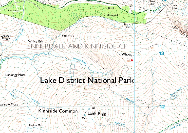
Whoap |
 |
 |
Overview |
 |
|
| Height: |
1676 Feet - 511 Metres |
| Grid Ref: |
NY 099 128 |
| Area: |
Western |
| Group: |
W/LAK |
| Ordnance Survey: |
OL4 |
|
| |
|
Map and Photo Gallery |
|
|
|
| |
|
Walks including Whoap are:- |
|
|
Caw Fell from Cold Fell Road |
|
|
 |
|
13th May 2023 |
| ASCENT: |
2,883 Feet - 878 Metres |
| MILES: |
12.6 |
| WAINWRIGHTS: |
4, Grike - Crag Fell - Caw Fell - Lank Rigg |
| ROUTE: |
Cold Fell Road - Blakeley Moss - Red Moss - Grike - Crag Fell - Black Pots - Iron Crag (Ennerdale Fell) - Caw Fell - Iron Crag (Ennerdale Fell) - Whoap - Lank Rigg - Whoap Beck - Cold Fell Road |
|
| |
|
Walking the Wainwrights in 30 Walks Walk 11 - Caw Fell to Grike from Monks Bridge |
|
|
|
|
30the April 2016 |
| ASCENT: |
3,200 Feet - 975 Meters |
| MILES: |
14.7 |
| WAINWRIGHTS: |
4, Caw Fell - Lank Rigg - Crag Fell - Grike |
| ROUTE: |
Monks Bridge - Tongue How - Worm Gill - Caw Fell - Iron Crag - Whoap - Lank Rigg - Whoap - Crag Fell - Grike - Blakeley Moss - Kinniside Stone Circle |
|
| |
|
Grike, Crag Fell & Lank Rigg from Cold Fell Road |
|
|
|
|
7th February 2015 |
| ASCENT: |
2,010 Feet 613 Meters |
| MILES: |
7.7 |
| WAINWRIGHTS: |
3, Grike – Crag Fell – Lank Rigg |
| ROUTE: |
Cold Fell road – Blakeley Moss – Grike – Crag Fell – Black Pots – Whoap – Lank Rigg – Lankrigg Tarn – Lankrigg Moss – River Calder – Cold Fell road |
|
| |
| Back to top |
 |
|