 |
Beda Fell |
 |
 |
Map and Photo Gallery |
 |
|
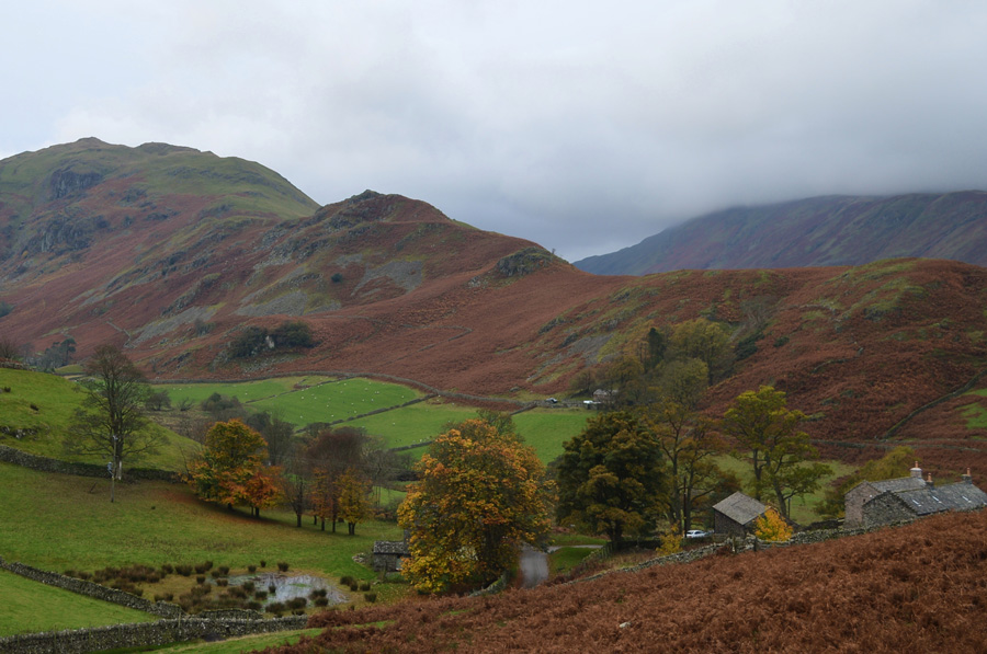 |
| Beda Fell and Winter Crag seen over the Martindale valley. |
 |
| Beda Fell and Winter Crag seen over the Martindale valley. |
|
| |
|
There are 9 walks to choose from including Beda Fell |
|
|
Martindale's Bannerdale Horseshoe |
|
|
 |
|
6th September 2025 |
| ASCENT: |
2,780 Feet - 847 Metres |
| MILES: |
9.5 |
| WAINWRIGHTS: |
5, Beda Head - Angletarn Pikes - Brock Crags - Rest Dodd - The Nab |
| ROUTE: |
Martindale New Church - Martindale Old Church - Winter Crag - Beda Head (Beda Fell) - Bedafell Knott - Heckbeck Head - Angletarn Pikes - Angletarn Pike South Top - Angle Tarn - Cat Crag - Brock Crags - Satura Crag - Rest Dodd - The Nab - Below Nab End - Martindale - Martindale Old Church - Martindale New Church |
|
| |
|
A Boredale Circuit |
|
|
|
|
25th February 2023 |
| ASCENT: |
2,547 Feet - 776 Metres |
| MILES: |
8.1 |
| WAINWRIGHTS: |
3, Beda Fell - Angletarn Pikes - Place Fell |
| ROUTE: |
Martindale New Church – Martindale – Winter Crag – Beda Fell – Bedafell Knott – Heckbeck Head – Angletarn Pikes – Boredale Hause – Steel Edge – Place Fell – Low Moss – High Dodd - Garth Head Farm – Martindale New Church |
|
| |
|
Walking the Birketts, Martindale's Bannerdale Horseshoe |
|
|
|
|
20th October 2018 |
| ASCENT: |
2,764 Feet - 843 Metres |
| MILES: |
9.5 |
| BIRKETTS: |
6, Beda Head (Beda Fell) - Angletarn Pike North Top - Angletarn Pike South Top - Brock Crags - Rest Dodd - The Nab |
| ROUTE: |
Martindale New Church - Martindale Old Church - Winter Crag - Beda Head (Beda Fell) - Bedafell Knott - Heckbeck Head - Angletarn Pike South Top - Angletarn Pike North Top - Angle Tarn - Cat Crag - Brock Crags - Satura Crag - Rest Dodd - The Nab - Below Nab End - Martindale - Martindale Old Church - Martindale New Church |
|
| |
|
Walking the Wainwrights in 30 Walks - Walk 20 Fourteen Fells east of Ullswater |
|
|
|
|
3rd July 2016 |
| ASCENT: |
4,790 Feet - 1,460 Meters |
| MILES: |
19.9 |
| WAINWRIGHTS: |
14, Bonscale Fell - Arthurs Pike - Loadpot Hill - Wether Hill - High Raise (Martindale) - Kidsty Pike - Rampsgill Head - High Street - The Knott - Rest Dodd - The Nab - Brock Crags - Angletarn Pikes - Beda Fell |
| ROUTE: |
Martindale New Church - Mellgaurds - Bonscale Pike - Top of Swarth Beck - Arthurs Pike - Loadpot Hill - Wether Hill - Red Crag - High Raise (Martindale) - Rampsgill Head - Kidsty Pike - Straights of Riggindale - High Street - Straights of Riggindale - The Knott - Rest Dodd - The Nab - Satura Crag - Brock Crags - Angletarn Pikes - Heckbeck Head - Beda Knott - Beda Fell - Winter Crag - Martindale Old Church - Martindale New Church |
|
| |
|
Hallin Fell and Beda Fell via Boredale |
|
|
|
|
8th November 2015 |
| ASCENT: |
2,021 Feet - 616 Meters |
| MILES: |
7.7 |
| WAINWRIGHTS: |
2, Hallin Fell - Beda Fell |
| ROUTE: |
Martindale New Church - Hallin Fell - Hause Farm - Howgrain Beck (Bridge) - Boredale - Boredale Hause - Bedafell Knott - Beda Fell - Beda Head - Christy Bridge - Martindale Old Church - Martindale New Church |
|
| |
|
Angletarn Pikes, Beda Fell & Ullswater |
|
|
|
|
5th April 2014 |
| ASCENT: |
2,300 Feet – 702 Meters |
| MILES: |
10.5 |
| WAINWRIGHTS: |
2 Angletarn Pikes – Beda Fell |
| ROUTE: |
Patterdale School – Rooking – Boredale Hause – Angletarn Pikes – Heck Crag – Bedafell Knott – Beda Fell – Beda Head – Winter Crag – Doe Green – Sandwick – Ullswater shore path – Patterdale School |
|
| |
|
Beda Fell to Place Fell from Martindale |
|
|
|
|
1st December 2013 |
| ASCENT: |
2,714 Feet 827 Meters |
| MILES: |
9 |
| WAINWRIGHTS: |
3, Beda Fell – Angletarn Pikes – Place Fell |
| ROUTE: |
The Hause – Martindale – Nickles – Beda Fell – Bedafell Knott – Heckbeck Head – Angletarn Pikes – Angle Tarn – Boredale Hause – Steel Edge – Place Fell – Hart Crag – Low Moss – High Dodd – Sleet Fell – Garth Head Farm – The Hause |
|
| |
|
The Martindale Horseshoe |
|
|
|
|
19th May 2013 |
| ASCENT: |
4,007 Feet, 1,221 Metres |
| MILES: |
12 |
| WAINWRIGHTS: |
9, Beda Fell – Angletarn Pikes – Brock Crags – Rest Dodd – The Knott – Rampsgill Head – High Raise – Wether Hill – Steel Knotts (Pikeawassa) |
| ROUTE: |
Martindale New Church – Martindale Old Church – Winter Crag – Beda Fell – Bedafell Knott – Angletarn Pikes – Brock Crags – Satura Crag – Rest Dodd – The Knott – Rampsgill Head – High Raise – Raven Howe – Red Crag – High Street Roman Road (Course Of) – Wether Hill – Brownthwaite Crag – Steel Knotts (Pikeawassa) – Birkie Knott – Lanty Tarn – Martindale New Church |
|
| |
|
Deluge On The Far Eastern Fells |
|
|
|
|
16th July 2011 |
| ASCENT: |
3,261 Feet, 992 Meters |
| MILES: |
12.5 |
| WAINWRIGHTS: |
7, Beda Fell, Brock Crags, The Knott, Rampsgill Head, High Raise, Rest Dodd & The Nab |
| ROUTE: |
|
|
| |
| Back to top |
 |
|

